

Maricopa County
Luke Auxiliary Field #6
Built in 1943, this satellite airfield was used for emergency landings & training missions.
Luke Auxiliary Field #6, also known as Goodyear Field, was a satellite airfield constructed during WWII to support air traffic and training that took place at nearby Luke Air Force Base. The field consisted of numerous runways arranged in a triangular configuration with minor facilities to support training missions. Luke Aux. #6 was one of several fields constructed in the area, with several additional fields built northwest and southwest of the base.
In 1940, U.S. Army officials were sent to Arizona to determine a site for a new Army Air Corps training field. Naturally, Phoenix’s warm weather, lack of snow, and plenty of open area proved to be very favorable. The City of Phoenix purchased 1,440 acres of land to establish the new base, which began construction in March of 1941.
Work was completed partially by Del Webb Construction Co. (the same company that established Sun City). Originally called the Litchfield Park Air Base, the base was renamed Luke Field after a base in Pearl Harbor, Hawaii released the name. 2nd Lt. Frank Luke Jr. was a fighter ace in WWI and received the posthumous Medal of Honor. By June of 1941, Luke began training fighter pilots. The first class of pilots graduated in August of that same year, but had to use the nearby Sky Harbor Airport until the base was fully completed.
Two North-American AT-6C trainers flying in the vicinity of Goodyear Field in 1943. [5]
As World War II raged on, flight training increased at Luke Field and thousands of pilots were going through advanced fighter school using the AT-6 Texan. As training expanded, the need for emergency airfields in the nearby vicinity arose. Additional airfields along flight routes would allow for emergency landings and better training options. In 1943, Goodyear Field -- also called Luke Auxiliary Airfield #6 -- was constructed as one of several satellite fields in the area.
Goodyear Field was built for around $263,000. It initially appeared that the field was constructed with two runways, with a long taxiway connecting them together. While most auxiliary fields featured only landing runways, Goodyear Field featured separate facilities including buildings & barracks for crew chiefs, pit toilets, crash truck shed, and even a control tower. The cost of the buildings alone were estimated at nearly $25,000.
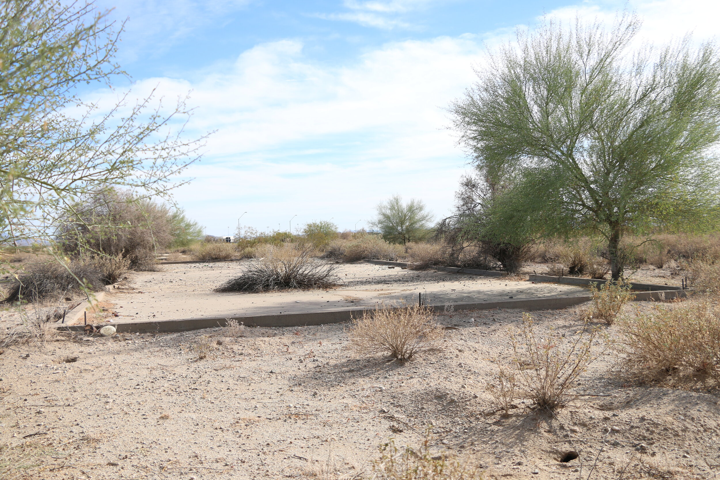
‘L280’ remains painted on a section of remaining asphalt. This does not appear to be original markings.
The parking apron and the foundations of support buildings on the east end of the field today.
By sometime in 1945, it appeared that the third taxiway was eventually converted to an additional runway. This gave Goodyear Field three 4,000’ by 300’ paved runways positioned in a variety of landing orientations. The triangular configuration of the field meant that no matter the wind direction, at least one runway would be suitable for landings. Goodyear Field was declared excess in 1949 and deeded to the State, however later that year it was reopened and expanded.
Goodyear Field continued to be used by flight training operations out of Luke. It was used for emergency landings, dart target launchings, and emergency drops during missions. Sometime before 1956, the NE/SW, left most runway was expanded another 1300’ to the north. The field was declared excess again in 1957 but remained open for emergency landings for several years after. By 1971, it was labeled as closed on sectional charts. It is unclear if the Army Air Corp (later redeveloped as the Air Force) came into clean up/tear down facilities.
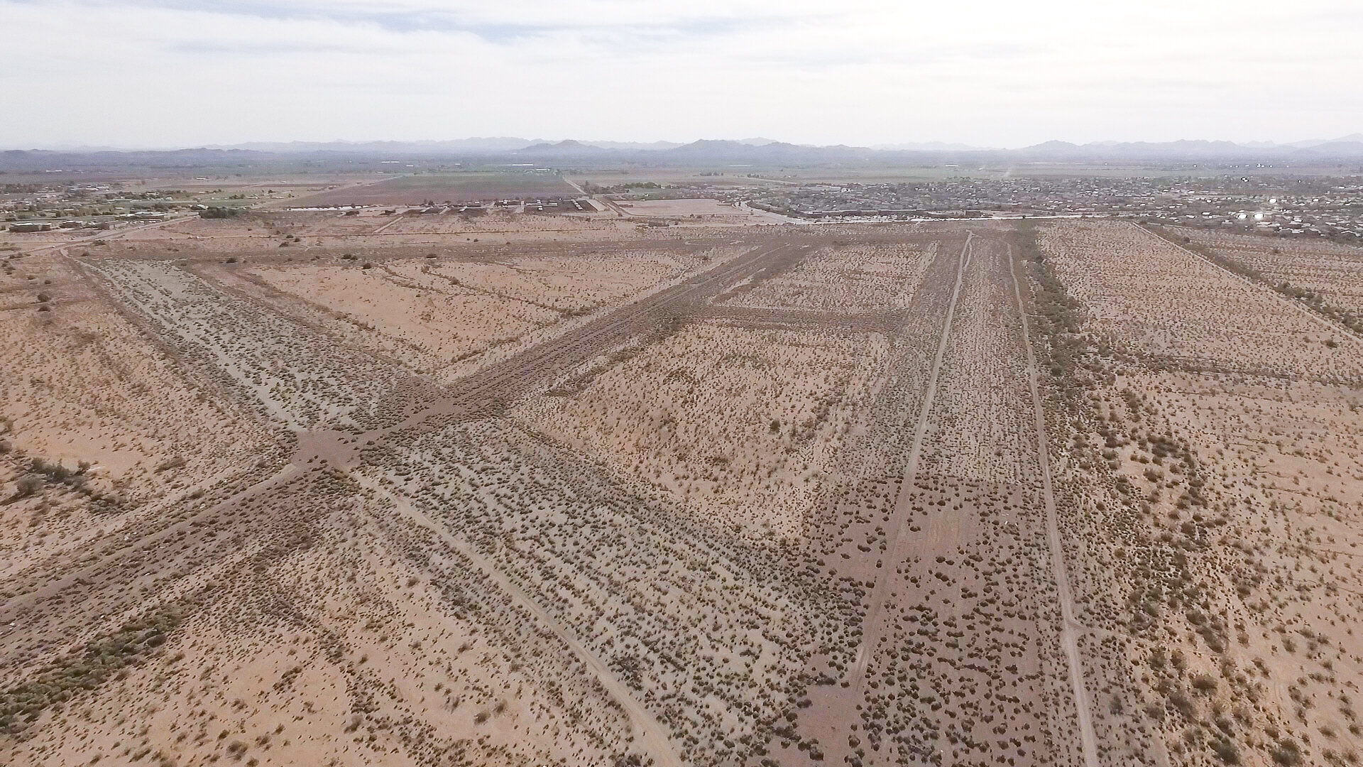
Today, Goodyear Field remains relatively preserved. All three runways remain, although they have deteriorated and remain overgrown. A few sections of pavement remain scattered around the field and along the taxiways. Small cement foundations can be found near the parking apron on the east side of the field, but no discernible buildings can be made out. A runway marking “L280” appears to remain on the southwestern corner of the field, however it does not seem like this was original Air Force markings. Limited online research suggests that this was created more recently by the Lufthansa Flight Academy ‘L280 crew’. Lufthansa is a German airline that trains out of the nearby Phoenix-Goodyear Airport and it is unclear if they ever used Luke Aux. #6.
Goodyear Field remains a unique piece of Air Force history hidden among modern neighborhoods and development. You would never know it is there from passing by on the road, but it is abundantly clear when looking at satellite imagery of the West Valley. While not much remains today, it makes for an interesting visit. Most of the property is still owned by the State, and a State Trust Land Permit is required. The northernmost portion of the field sits on private property. Luke Aux. #6 can be found on the northwest corner of Verrado & Yuma Road in Buckeye.


Sources:
Freeman, Paul. "Luke Field Auxiliary Airfield #6 / Goodyear Field / Luke Air Force Auxiliary Airfield #6, Goodyear, AZ." Abandoned & Little-Known Airfields: Southwest Phoenix Area. Abandoned & Little-Known Airfields, 21 Sept. 2019. Web. <http://www.airfields-freeman.com/AZ/Airfields_AZ_Phoenix_SW.htm#goodyear>
"Luke Air Force Base." Wikipedia. Wikimedia Foundation, 12 Oct. 2020. Web. 8 Oct. 2020. <https://en.wikipedia.org/wiki/Luke_Air_Force_Base>
Phoenix Sectional Chart (March 1946), Image provided by: Library of Congress, Washington, DC. Link to the full image: https://www.loc.gov/resource/g3701pm.gct00089/?sp=4660
Phoenix Sectional Chart (January 1969), Image provided by: Library of Congress, Washington, DC. Link to the full image: https://www.loc.gov/resource/g3701pm.gct00089/?sp=4591
Image of 2 North-American AT-6C Texan Trainers sourced from Wikipedia. Image is the work of a U.S. Air Force employee and is originally from the National Museum of the USAF (image ref: 090821-F-1234S-001 ): https://commons.wikimedia.org/wiki/File:AT-6C_Texans_in_flight_1943.jpg
Modern-day satellite image of Goodyear Field sourced from Google Earth, all rights reserved.